Hurricane Erin Breaks Records as Atlantic’s First Major Hurricane of 2025
Hurricane Erin has shocked forecasters by becoming not just the first hurricane of the 2025 Atlantic season, but also the first to hit Category 5 intensity. The storm's story started on August 11, when a tropical wave formed near Cape Verde. At first, it looked pretty average. Then, as it spun across the Atlantic, the situation flipped fast. Erin ramped up to hurricane status by August 15 and then, within just 24 hours, pulled off an explosive burst of intensification that left meteorologists stunned.
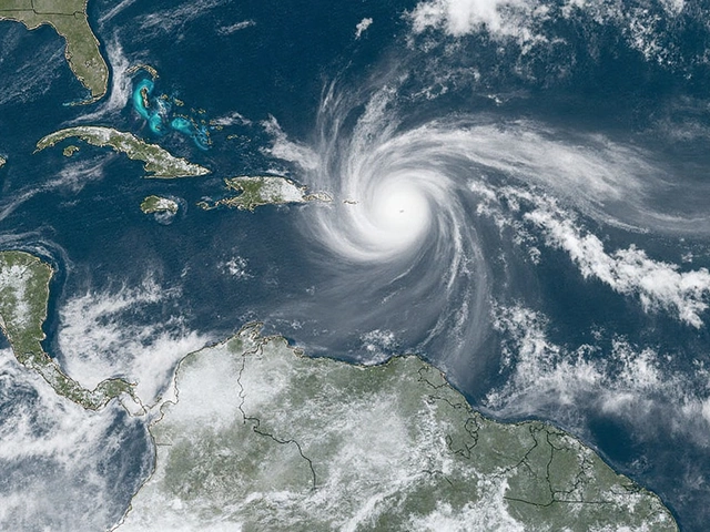
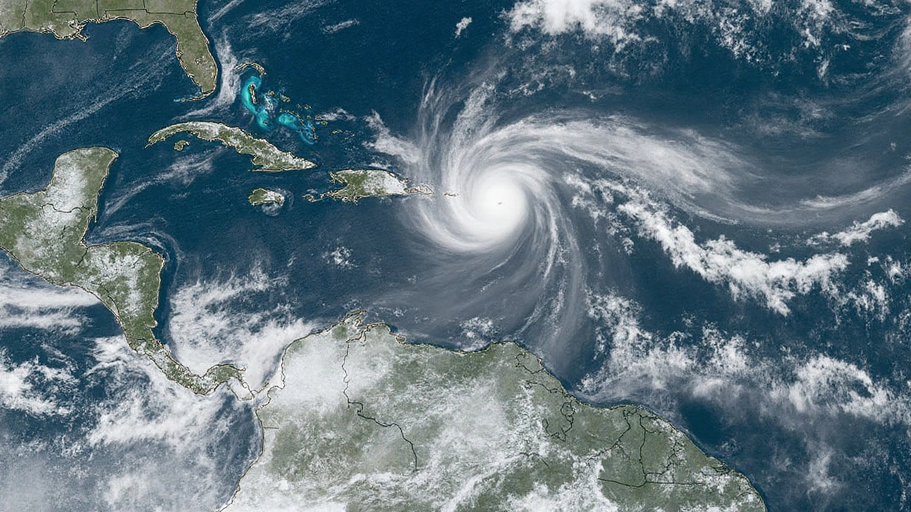
On August 16, Erin launched from a mere Category 1 into a monster Category 5 storm—reaching 160 mph sustained winds and a minimum pressure of 915 mb. How did this happen? Ocean water in the Atlantic was unusually warm, with scientists saying this kind of heat-fueled jump is up to 100 times more likely today because of human-driven climate change. Many experts call Erin’s leap to Category 5 a textbook example of what warmer oceans can do. The hurricane’s power didn’t just stick around—it danced between Categories 3, 4, and 5 through the next several days as it grew larger and wrestled with wind shear that tried to tear it apart, losing some strength only to regain it moments later.
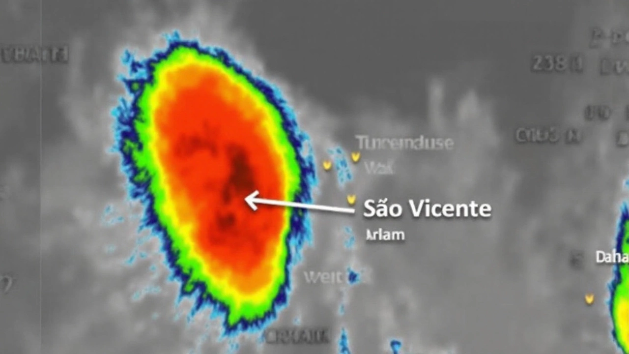
Before it even became a hurricane, Erin’s early rains caused chaos in Cape Verde. São Vicente island saw over 178mm fall in just five hours, leading to flash floods that killed nine people and forced disaster declarations for São Vicente and Santo Antão. That kind of rainfall in so short a window hit hard, especially for small island communities with little warning or capacity to handle such deluge.
Broad Impacts Across Caribbean and Threats Closer to Home
Once Erin moved past Cape Verde and intensified, its massive bands began battering the Caribbean. Puerto Rico got hammered over the weekend, with more than 80,000 losing power and major flood watches stretching across both Puerto Rico and the Virgin Islands. The Turks and Caicos and the Bahamas weren't spared either. Erin’s reach brought heavy rain and wild winds, with up to 6 inches of rainfall forecast in affected areas. By Monday, Erin slid east of the central Bahamas, moving northwest at 10 mph while dangling the threat of worse to come.
And here’s where the tension ramps up. Even though Erin’s center isn’t on a direct collision course with the U.S. coast, its sheer size and muscle are already making life tough for people along the Eastern Seaboard. In North Carolina’s Outer Banks, officials have issued a wave of warnings—mandatory evacuations, storm surge alerts, and high surf advisories. Beaches there could see waves cresting 15 feet, with pockets reaching a wild 20 feet, and a storm surge that might climb to 4 feet. Lifeguards and locals are bracing for dangerous rip currents and flooding, even as Erin stays a little offshore.
This zone includes popular summer spots and remote communities with only one way in and out. Emergency teams started moving people out ahead of time, knowing conditions can switch from calm to hazardous in just a couple of hours. High water and howling winds threaten to flood low-lying areas, trap residents, and tear up piers and roads—problems that go way beyond a typical summer storm.
Looking ahead, forecasters say Erin will keep heading northwest, then turn north, squeezing between Bermuda and the U.S. east coast midweek. The hurricane’s staying strong, with models suggesting it’ll maintain major hurricane status into Wednesday, only weakening once it sails into cooler waters and open ocean later in the week.
What does all this mean for people across the Atlantic basin? It’s another reminder that hurricane season is starting off with a heavy punch, and Hurricane Erin is making it clear that storms are growing faster and hitting harder in a warmer climate. Meteorologists keep stressing how ocean heat—fueled by decades of carbon emissions—is now the main engine for these record-breaking storms. Since 1970, oceans have sucked up about 93% of the extra heat from human-caused warming, and we’re beginning to see the results play out more often with hurricanes like Erin.
For East Coast residents, beachgoers, and business owners, the next few days are all about watching warnings and playing it safe. For scientists, Erin is another stark case study on climate's heavy hand in shaping today's hurricanes. As this storm continues to swirl, its story isn’t over—it’s still rewriting the rules on Atlantic hurricane season in real time.